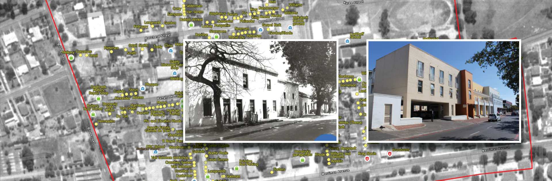
The entrance to the parking area of the Bergzicht Plaza building used to be a family home in Andringa Street in the sixties.
Mapping Die Vlakte: Restitution for a displaced community
- Former residents of Die Vlakte gathered at SU for the presentation of a collaborative research project that digitally maps the history of the community displaced by apartheid-era forced removals.
- Using advanced GIS and counter-surveying methods, researchers and community members identified over 320 historical sites, transforming memories into a living digital archive of homes, shops, and shared spaces.
- The project has opened dialogue about restitution and memory, with attendees committing to develop the map into a community-led walking route to educate future generations about Die Vlakte’s history.
The streets of Stellenbosch hold memories that are largely hidden to the casual passer-by. Just over 60 years ago, a vibrant community in the heart of the town met a cruel fate that has since been hidden from public view. On 25 September 1964, 757 families were evicted from their homes because of the declaration of the central area known as “Die Vlakte” as a white group area.
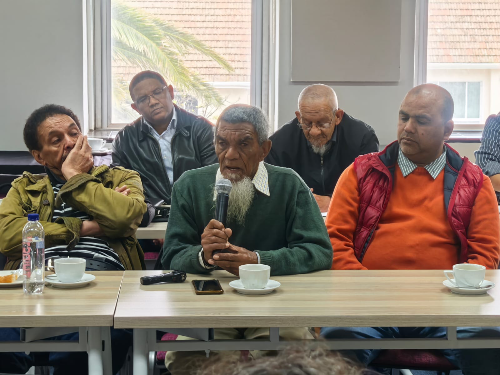
At an impactful event held recently at Stellenbosch University’s (SU) Faculty of Education, “Mapping of Die Vlakte through Counter-Surveying”, former residents were invited to receive the fruits of a research project using advanced technology to restore dignity to a community still affected by the traumatic forced removals under apartheid.
Robbed of identity
“Die Vlakte” referred to an area in Stellenbosch that was geographically demarcated by Muller Street, Ryneveld Street, Banghoek Road, Smuts Street, Merriman Avenue and Bird Street. After the forced removal of about 5 000 people, the community was fractured into three areas on the outskirts of the town, including Cloetesville, Kayamandi and Idas Valley.
The Mapping Die Vlakte gathering, facilitated by Prof Aslam Fataar, distinguished professor in the Department of Education Policy Studies at SU, marked the conclusion of a counter-surveying project undertaken by researchers at the University of Cape Town (UCT) in collaboration with members of the Stellenbosch Vlakte Community Forum.
Counter-surveying involves using surveying and mapping techniques to find and mark out the locations of sites that no longer physically exist – such as houses demolished during apartheid – and to create a spatial archive of stories of those sites. During this project, researchers worked closely with former residents to help map and preserve the memory of the historic community of Die Vlakte.
For Joseph Jacobs, a resident of Cloetesville and representative of the Stellenbosch Vlakte Community Forum, those memories are rooted in lives disrupted and homes erased. Speaking at the meeting, he reminded the audience that Die Vlakte had once been a diverse, close-knit community before apartheid forced removals scattered families and shattered a way of life.
“My parents and their families never spoke about this history,” Jacobs said. “They were robbed of a sense of belonging, a sense of identity. It was too painful to talk about. But if you have memory, you have roots,” he emphasised.
Counter-surveying as a tool of restoration
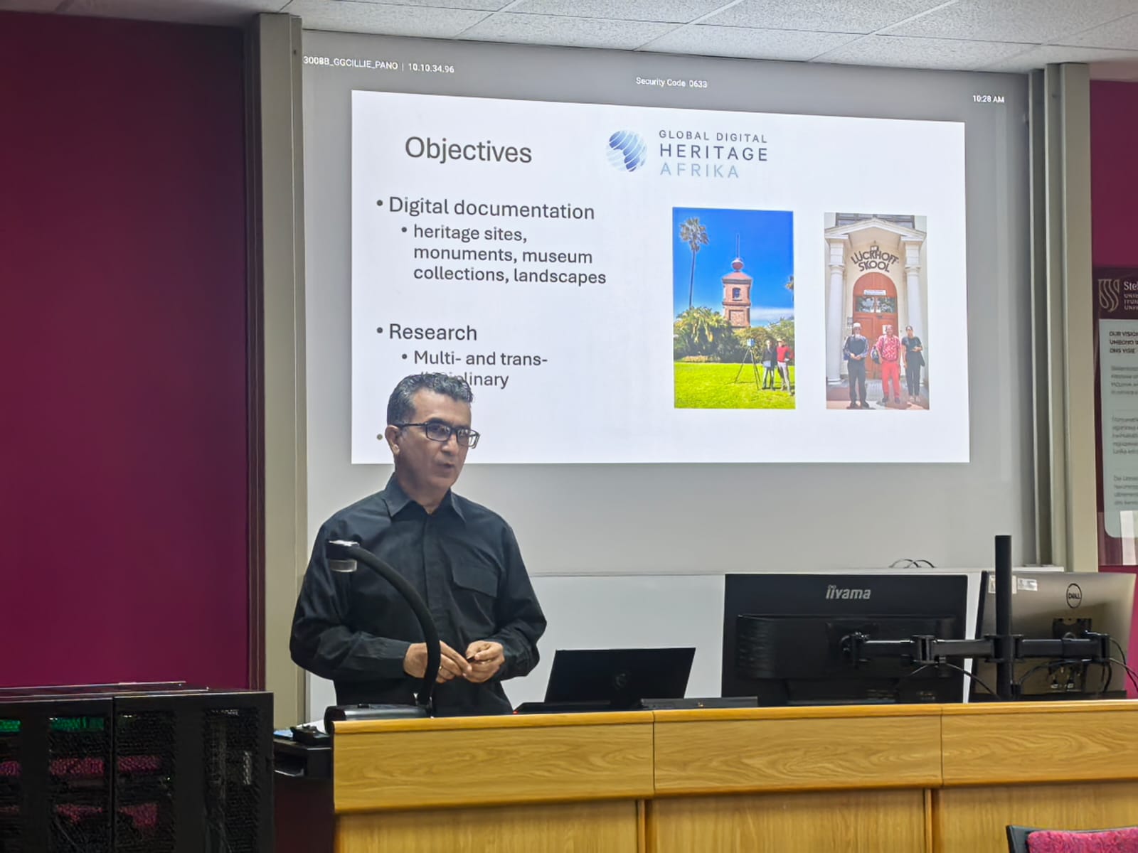
The presentation was delivered by Dr Siddique Motala from the UCT’s Global Digital Heritage Africa research grouping and co-creator of the counter-surveying methodology. His interdisciplinary work links geography, digital heritage and social justice, offering a way to literally put erased communities back on the map.
By walking ex-residents through the “ghosts” of their homes using archival maps and digital overlays, counter-surveying transforms memory into spatial knowledge. Motala described the project in Stellenbosch as both technical and deeply human: “When former resident Mr Mogamad Ras walked us through his old house in Andringa Street, he was not only pointing out walls and windows. He was re-inscribing family life, community networks and stories that apartheid tried to erase.” The Ras family had lived in Stellenbosch for close to a century before being evicted.
In a presentation illustrating the project’s output, master’s graduate Tlotliso Mokomane who specialises in geographic information systems (GIS), spatial analysis and historical preservation, showed a photo of Ras standing in front of 107 Andringa Street where he grew up. This site is now the entrance to the parking area of the Bergzicht Plaza building. “We returned to the site with Mr Ras, and he showed us where the living room was, where the kitchen was and the room where he slept with his brothers and sisters,” she explained.
The interactive digital map, created through GIS technology and the testimony of community members, documents over 320 points in Die Vlakte, including homes, schools, shops and social spaces. Beyond an exact location, each point also carries the stories of those who once occupied it.
Ras helped the researchers pinpoint places like the Gaiety Bioskoop, the Habib Winkel, Salie Bert’s tailor shop and Toefy’s Cash Store. As Motala demonstrated the interactive map he credited Ras’ remarkable memory with bringing history to life. “In every street in Die Vlakte, we can now tell you the names of the people who lived there,” Motala noted as he highlighted places on the map. “The children in this house were Pietie, Abie, Rollie and Sheila. This was the Abraham family house. Mr Manual, a musician, lived here. Mr Ras’ memory is amazing…”
Community voices
The event drew a diverse audience of elderly former residents, community members, activists and academics. Several former residents such as Yusuf October spoke movingly about the pain of removal, the resilience of their families and the importance of having their stories recorded.
For Moegammad Tahier Kara, a Master’s student in education at SU and a resident of Idas Valley, the workshop held personal and academic resonance. “Attending the workshop was deeply meaningful for me,” he said. “It brought into focus the themes I have been working on around memory, erasure and reparations, but in a way that was grounded in physical space and lived history. Walking through the narratives of the people who once occupied these spaces before forced removals, reminded me that memory is not abstract, it’s embodied in place, community and belonging. Being part of this process felt like stepping into the work of re-inscribing silenced voices into the landscapes where they belong.”
Ongoing dialogue
For SU, the event also carried profound historical significance. It placed the institution, whose expansion once came at the cost of communities like Die Vlakte, within an ongoing dialogue about redress and reconciliation. As Fataarnoted, the counter-surveying project is not simply about technical mapping. It’s about truth-telling, acknowledgement and ultimately about restitution.
By recording the insights of ex-residents and plotting them back into the geography of Stellenbosch, counter-surveying makes visible what was lost and ensures that future generations can trace their roots back to Die Vlakte. It lays a foundation for conversations about justice, belonging and the kind of future communities want to build.
- An outcome of the discussion was that people who attended committed themselves to reconvening to discuss how the map can be further developed and possibly form the basis of a restitution and memory walking route to facilitate education of youth among others. This process would be owned by the affected community with academics and others invited to contribute.